Peru
- abundantlyclare

- Jul 27, 2025
- 11 min read
I left Washington, D.C. on September 28, headed for Lima. I had a layover in Bogota so I landed in Lima after midnight. I made my way to my hotel and took it easy in the morning, but then I set off to sightsee. I only had one full day in Lima before my tour of Peru set off, and I wanted to make the most of it. I had read that the two best neighborhoods to prioritize were Barranco and Miraflores, so I headed to Barranco first.

My first stop was the Plaza de Armas in Barranco. It was a busy day, with market stalls set up and lots of people on the street. The Spanish influence from colonialization was very obvious to me, especially in the architecture, as soon as I arrived in Peru.

Not far from the plaza is the Puente de los Suspiros, or the Peruvian Bridge of Sighs. According to Wikipedia, "due to the popular tradition that indicated the place as a meeting point for lovers and romances, the bridge became known as the 'bridge of sighs.'" The pathway under the bridge also slopes down until it reaches the sea.

I hopped in an Uber and went over to the Plaza Mayor. I thought I got lucky because there was some kind of parade going on around the square (behind me when I took this photo), but the more time I spent in Peru, I discovered they love any excuse for a party or a parade. No exaggeration, I saw probably 4 or 5 in different locations during the two weeks I was there—including a second one later the same day in Lima.
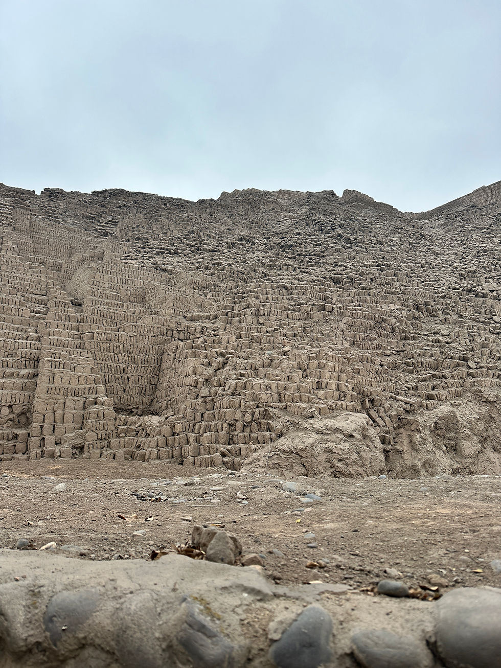
I then went to visit Huaca Pucllana. According to Wikipedia, Huaca Pucllana is "a great adobe and clay pyramid built from seven staggered platforms. It served as an important ceremonial and administrative center for the advancement of the Lima Culture, a society which developed in the Peruvian Central Coast between the years of 200 AD and 700 AD." The Lima culture was pre-Inca, as a point of reference.
I then joined a walking tour in the afternoon that met in Kennedy Park, which is famous for being a refuge for stray cats. Locals have created little cat homes in the park and regularly set out cat food for them. The park was originally called Parque Central, but was renamed to honor President Kennedy's support for Peru, particularly his role in the Alliance for Progress initiative. While I was in Kennedy Park, I had my first taste of chicha morada, one of many drinks in Peru made from corn. That drink in particular is made from dried purple corn, and they serve it sweet and cold, which I really enjoyed.

The tour took us to Parque del Amor, home of the famous sculpture "El Beso." The park overlooks the ocean and it was inspired by Parc Guell in Barcelona.

I thought it was so beautiful that the city of Lima is up on the hilltop but the sea is right below. And everything is so green!

I don't normally take food photos but I couldn't resist when I tried ceviche for dinner. Ceviche is the national dish of Peru, and it's raw fish that's marinated in lime juice. It was my first time trying it and I really didn't know what to expect, but I thoroughly enjoyed it.
I made my way back to the hotel after dinner, because I had a meeting that night with the tour group I'd be traveling with for the next two weeks. We met and went over the itinerary for the next couple of weeks to see what we had to look forward to.
In the morning, we set off for Nazca, home of the famous Nazca lines. According to Wikipedia, "the Nazca lines are a group of over 700 geoglyphs made in the soil of the Nazca Desert in southern Peru. They were created between 500 BC and 500 AD by people making depressions or shallow incisions in the desert floor, removing pebbles and leaving different-colored dirt exposed."
I have to be totally honest here: I was thrilled to be in Peru, but many of the sightseeing or touristy opportunities that came up really did not excite me. Civilization in Peru is similar to Egypt; they have proof of people living there from thousands of years ago, which makes it an absolutely fascinating place to visit for people who are interested in archaeology, anthropology, sociology, etc. Unfortunately for me, I'm simply not interested in those things. I really don't care to see ancient shards of pottery in a museum or anything in that wheelhouse, so I fully acknowledge Nazca was a low point of the trip for me.
We traveled by bus for about 7 hours to reach Nazca and then had a relaxing night in the hotel.

In the morning, some people elected to take a scenic flight over the Nazca lines to see them from above; I personally chose to climb the viewing tower instead, and it was definitely something to see the lines from above and know that they were more than 2,000 years old. The shape you can see in the desert behind me is supposed to look like a tree.

This was the viewing platform to see the lines from above.
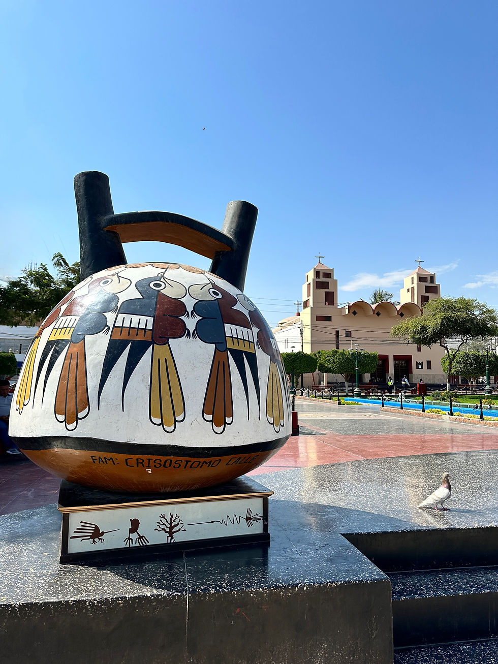
After we saw the lines in the morning, we explored in the town of Nazca. References to the shapes in the desert are everywhere, as you can see on this pottery in the town square.

We then took an overnight bus to the second-largest city in Peru, Arequipa. The city is located at the foot of the volcanic slopes of El Misti, a perfect conical peak that towers 19,000 feet above. The city itself was founded by the Spanish in 1540 on a former Inca settlement.

We then paid a visit to the extraordinary Santa Catalina Convent, a miniature walled citadel in the heart of Arequipa, which once housed 450 nuns and serving ladies in total seclusion for nearly four centuries.

Riddled with a network of cobbled streets, you can see the street sign carved into the side of the building. It was completely sequestered for 400 years, from 1580 to 1970. Nuns still live in the northern area of the complex.

Around sunset, I went to the Yanahuara Scenic Overlook, which perfectly frames Mount Misti.

I love how you can see the reaches of Arequipa that go right up to the volcano (The volcano is dormant, thankfully!).

In the morning, we hit the road again, heading into the Altiplano, or the high altitude tableland of central South America. Along the way, we saw herds of llamas' and alpacas' wild cousins, the guanaco and vicuña. The photo above is a herd of vicuña, which at one point were hunted almost to extinction for their soft wool. Thanks to government protections, their populations have bounced back in Peru and Bolivia.
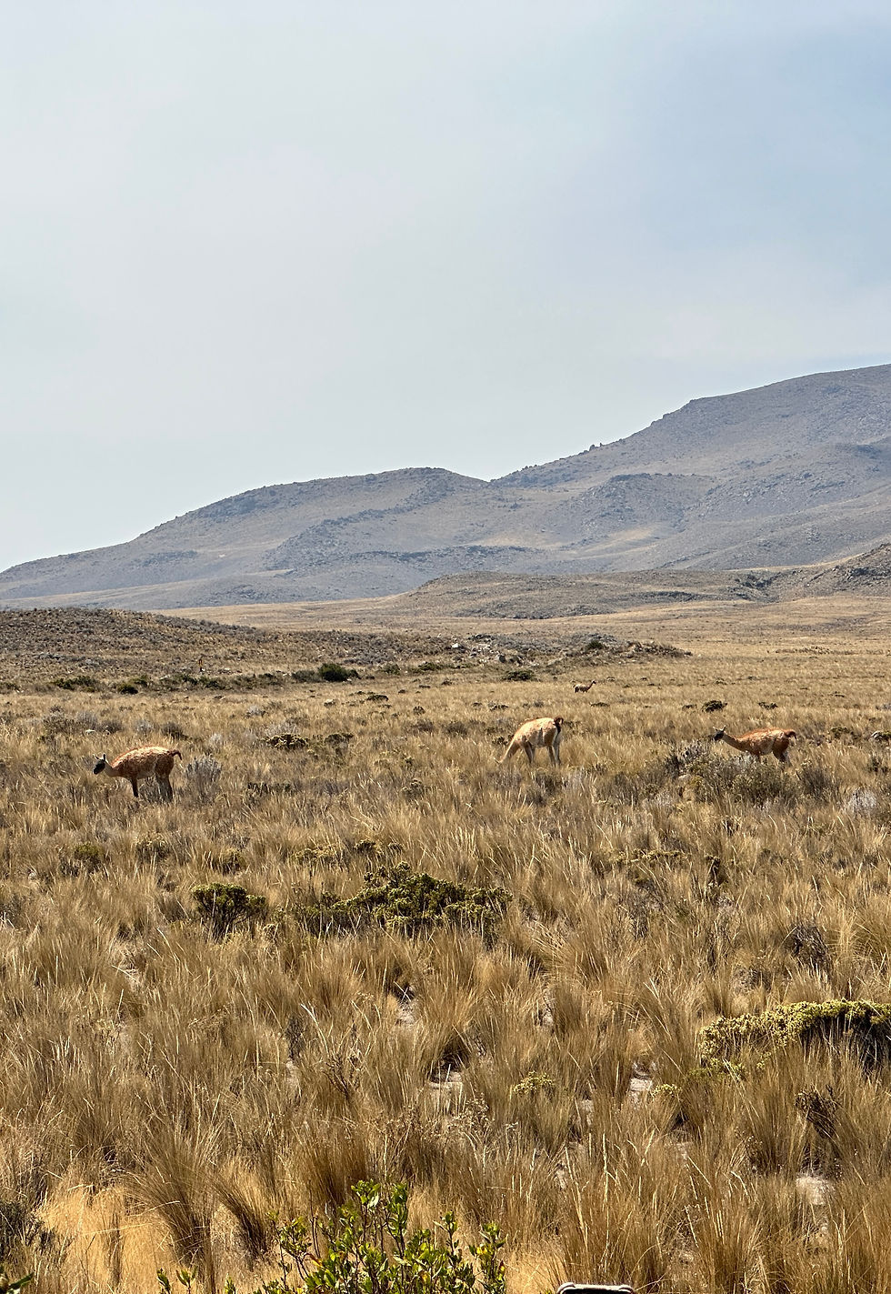
These are guanacos. Vicuña are small and have coloring almost like a fawn (like Bambi) and guanacos have black, hairless faces.

We stopped at a little farm along the way to snuggle with some of the llamas and alpacas! I'm sitting with a llama but the white one lying down on the left side of the photo, for example, is the most obvious alpaca; they are much fuzzier than llamas, especially near their faces!

We drove through the highest point of our trip going through the Patapampa Pass, and I had my first experience with altitude sickness. When I stepped off the bus to take a picture with this overlook, I immediately felt woozy and lightheaded. I get migraines regularly anyway, unfortunately, so I basically expected one today, since we were up as high as 16,000 feet (and I got one when we went to Pikes Peak in Colorado). The migraine hit not long after this photo and I actually got sick at lunch, then had to put myself to bed for the rest of the day once we arrived at the hotel. I missed out on the famous hot springs in Chivay, our destination that night, but what can you do?


I felt better when I woke up in the morning, and I can't imagine a much more scenic setting for a hotel!

The following day we headed out early to explore the breathtaking Colca Canyon. I read the brochure for this tour multiple times, and this section always jumped out at me: "A spectacular river gorge, the Colca Canyon measures twice the depth of the more famous Grand Canyon and at one time it was believed to be the deepest gorge on earth (until it was eclipsed by the deeper Cotahuasi Canyon). Today it allows us to discover a world of Andean villages and Inca terraces that make up one of the most outstanding natural settings in the Americas."

Colca Canyon is also famously a great place to see the Andean condor in their natural habitat. According to Wikipedia, "with a maximum wingspan more than 10 feet and weighing as much as 30 pounds, the Andean condor is one of the largest flying birds in the world, and is generally considered to be the largest bird of prey in the world." This juvenile landed right near us!

I think here you get a better sense of how deep the canyon is. The striking thing about the Grand Canyon is that it's flat all around the rim; Colca Canyon is formed from mountains themselves, and the drop behind me is staggering.

Another great view of the farming terraces in the valley leading up to the canyon. I was so excited about visiting this area and it still managed to surpass my expectations.
We spent basically the entire day in the bus, first driving out to Colca Canyon and then doubling back to go to Puno, the city on the edge of Lake Titicaca on the Peruvian side.

In the morning, we set out from Puno onto the lake. Our first stop was one of the floating reed islands, home to the Uros people who live on the lake itself. Their islands are made from totura, a reed-like papyrus that grows in the shallows and they use for nearly everything, including cooking and eating as well as the construction of their boats, homes, and the islands themselves. Basically everything in the photo above is made from reeds.

Here I think it's easier to see that I took this photo from a floating reed island. You can see Puno in the distance.

There are some more solid homes built on the floating reed islands, as well.


We spent the night on Taquile island in a homestay, with a family who made us dinner and shared some of their traditional songs with us around a campfire. It was an incredible experience. In the morning, we crossed the island to get to the boat pickup point. Lake Titicaca reminds me of the Great Lakes in the US; all you can see is water, all the way to the horizon! (It was also a three-hour boat ride to get back to Puno.)
We spent the night in Puno, and in the morning, we headed for Cusco.

Another day in the Andes, another breathtaking mountain vista. This is La Raya pass, which marks the continental divide, on the way to Cusco.

We also stopped at the Temple of Wiracocha in Raqchi. Built by the Incas in the 15th century, of course the Spanish destroyed most of it. According to Wikipedia, "Prior to its destruction by the Spaniards, the temple had what is believed to be the largest single gable roof in the Incan Empire."

We also stopped at Saint Peter the Apostle of Andahuaylillas Church, a 16th-century church they call the Sistine Chapel of the Andes. You're not supposed to take photos inside so this was the only sneaky one I got.
We spent most of the day traveling and finally made it to Cusco in the evening.

Our first stop in Cusco was Sacsayhuamán, a citadel built by the Incas in the 15th century. According to Wikipedia, "Dry stone walls constructed of huge stones were built on the site, with the workers carefully cutting the boulders to fit them together tightly." As you can see from the boulders in this photo, no mortar was used, and many of the walls are still standing. I love the view of the city spread out below the complex as well.

We then stopped at Manos de Comunidad, a textile company and museum. They have animals onsite to get the wool for their textiles, so we got to feed some of them!

They also had guinea pigs. Since Manos de Comunidad is a working farm, and guinea pigs are a delicacy in Peru, they are commonly seen on menus. I didn't try it but someone in my tour group compared it to eating chicken.

The Spanish architectural influence was noticeable all over Peru, but Cusco had the most European feel to me. We were walking around in San Blas, one of the artsy neighborhoods, and we turned a corner and I felt like I was in the Mediterranean.

The Plaza de Arms in Cusco is nothing to sneeze at, either. This is the Cusco Cathedral.

The Cathedral is on the left and that's another church in the center right: the Church of the Society of Jesus. We had an incredible dinner right on the square that night, at the recommendation of our amazing tour guide Lys, and I had some of the best dessert I've ever had.

The next day, we a bus from Cusco to Ollantaytambo, then took a train to Aguas Calientes, the town that is the gateway to Machu Picchu. There are two ways to get to Machu Picchu: by a bus and train combo, or by hiking. The train is about 2 hours and then you get on a bus in Aguas Calientes and go up switchbacks, one right after the other, for about 30 minutes to get to the top of the mountain. The hike along the Inca Trail takes 4 days and 3 nights. Obviously I never even considered doing the hike, but major kudos to anyone who does (including my amazing friend Ailbhe, in case she reads this!). We had to climb up a large number of stairs when we got off the bus and then down into the archeological site, and that was enough of a workout for me. The train ride was breathtaking, as you can see, so I can only imagine how beautiful the hike must be.

I was so nervous about the weather, since Machu Picchu is often hidden by fog or low-lying clouds, and of course it started raining on our way there. But thankfully we had a perfect view!

And better yet, the sun came out! According to Wikipedia, "Machu Picchu is a 15th-century Inca citadel. Often referred to as the 'Lost City of the Incas,' Machu Picchu is one of the most iconic symbols of the Inca civilization and a major archaeological site in the Americas. Built around 1450, it is believed to have served as an estate for the Inca emperor Pachacuti, though no contemporary written records exist to confirm this. The site was abandoned roughly a century later, likely during the Spanish conquest. Although known locally, it was brought to international attention in 1911 by American historian Hiram Bingham III. It was named a New Wonder of the World in 2007."

The Spanish never knew about Machu Picchu, which is why it's still so well-preserved. If they knew about it, they surely would've destroyed it the same way they did the Temple of Wiracocha above. It was a crazy experience to walk around among the ruins. This was a city, so many of the smaller "rooms" you can see here were single-family dwellings.

Another great example of Incan terrace farming, like what they still do in the Colca Canyon. They utilized gravity to water the crops, and I believe the farming areas were communal.
In the evening, we went to the hot springs for which Aguas Calientes is named, so I got my hot springs experience after all.
The following day was a pretty chill day for me. There were optional hikes to do in and around the archeological site, which of course I opted out of, and then we took the train back to Ollantaytambo in the afternoon, and got off the bus to Cusco in the evening.
For my last full day in Peru, I was really torn because there were so many things I wanted to do and see in the Sacred Valley of the Incas, near Machu Picchu. But I also pretty desperately wanted to see Rainbow Mountain, which is what I ended up doing. In hindsight, I should've given myself one extra day to see more of the sites in the Sacred Valley, but I'm so happy I went to Rainbow Mountain.

The mountain's real name is Vinicunca, but it's also known as Rainbow Mountain or the Mountain of Seven Colors. The mountain was "discovered" around 2013 when snow and ice covering the colorful mineral layers melted due to climate change. Due to its high elevation at more than 16,000 feet, the colors had always been covered up before. At this point, I was more acclimated to the high altitude, so I'm happy to report I didn't get sick while I was there.

The terrain surrounding Rainbow Mountain is also absurdly beautiful and stark, as you can see here.
I had a wonderful last day exploring in Peru before I set off to my next destination: Brazil!


Comments